
Population and geographic information of the districts and Ghazni province where projects have been implemented and implementing by HAALO.
Provincial profile for Ghazni Province:
Ghazni province is one of the 34 provinces of Afghanistan , centered on Ghazni city, which is one of the southeastern provinces of Afghanistan. Ghazni is the fifth most populous province of Afghanistan with a population of 1,325,113. In terms of administrative management, this province is divided into (19) nineteen districts and has an area of 22,461 square kilometers; Ghazni is considered one of the oldest regions in the world with an age of more than 1000 centuries.
Geography:-
Ghazni province is located in the center of Afghanistan between 32 degrees and 4 minutes and 9 seconds to 34 degrees and 13 minutes and 51 seconds of north latitude and 66 degrees and 49 minutes and 16 seconds to 68 degrees and 49 minutes “56 seconds of east latitude from the Greenwich meridian. The average length of this province in a straight line is 240 km and its average width in the east-west is about 181 km It is bordered by Zabul province in the west, Paktika province in the southeast and Uruzgan province in the west, and is 135 kilometers away from Kabul of the sea level is 2,183 and its area is 23,378 square kilometers, which is about one twenty-eighth or 3.5% of the total area of Afghanistan. Nawar district is the largest and Rashidan district is the smallest one.
The mountains of Ghazni Province are: Qada Barik in the northwest, Shenki in the south, Jarkneh in the southeast, Hindu Kush in the northeast, and Baba Mountain in the north. Ghazni Standing Water, Sardeh Dam, Sultan Dam, Zankhan Dam and Zardsang Dam are the important lakes of this province which play a major role in the agriculture of the region. The Ghazni Sea originates from the heights of Behsud and is established in the Nawar Band Sultan plain above it, and after passing through the city of Ghazni, it flows into the standing water of Ghazni in Nawa district.
Natural resources:-
Ghazni province has significant natural resources. According to the latest estimates of Afghan and foreign geologists, Ghazni is one of the richest lithium mining areas in the world. Gold and copper were also found in Zarakshan of Ghazni. The value of these mines is estimated at 30 billion dollars. The mines discovered in Ghazni are approximately 30% of the total mines of lithium, gold, and copper, as well as a percentage of the mines of silver, lead, zinc, and precious stones in Afghanistan. There are some minerals in Zarkashan Mountain in Maqoor district. There are some natural wild almond forests on an area of 2900 Ha in Qarabagh and Jaghatu districts. The total area for summer and winter pastures is 412380 Ha. There are three man made water reservoirs (Sarda, Zanakhan and Band Sultan) and two natural water bodies (Nowar and Muqar).
There are no major developments going on in Ghazni possibly due to the worsening security situation. Before war agriculture and livestock were the main sectors providing livelihoods to majority of the population but these sectors were badly hit by war as the majority of populations migrated to neighboring countries. There are some efforts for the recovery of agriculture and livestock sectors by different organization but due to persistent drought after 1999 and security situation these efforts are not fully successful.
Agriculture:-
According to the figure provided by department of Agriculture in Ghazni approximately 139,391 Ha of land is irrigated and 8,600 Ha is rainfed. But the total area on which crops were grown during 2005/06 is 118,001 Ha and the decrease in total cultivated area is due to the drought during the past six years.
The major sources of irrigation are Karezes, springs, wells and tube wells. It is noteworthy over here that the majority of the irrigation in the district is done through extensive network of Karezes. There are 70 canals, 1,280 Karezes and 223 springs in Ghazni province. Since 1995 people have started installing private tube wells ( Chaimeq ) for irrigation which has led to the going down of water table and drying of the Karezes as most of the people have dug wells to install pumps near intakes of Karezes. Most of the Karezes have collapsed during war and no proper repair as it is time consuming and need lot of financial resources.
Due to the favorable weather and relatively good rainfall, which often falls in the form of snow and rain in winter and early spring, all kinds of fruits and agricultural products specific to these regions are grown in Ghaznin. Also, due to the prosperity of livestock breeding, all kinds of domesticated animals are raised and kept there. Clothes made from the hair and skin of domestic animals is very important in this land, especially in the northern parts of Ghaznin. Sarde Band dam is located in Ander district near the border of Paktika Province. This dam is a large reservoir of water, which is vital for the irrigation of agriculture in the region.
Education:-
Ghazni, although compared to other provinces of the country, was the leader in the education sector; However, as a result of the wars of the last few decades, the education system of this province has also been damaged and schools are closed in most of the districts, which has caused the students of this province to be deprived of several educational courses. There are about 635 schools in Ghazni province, including several governance and private sector institutes which have 4,747 teachers and 145,986 students, and 15% of them are female. Ghazni University was established in 2007 and now has about 1500 students in four faculties of Education, Sharia, Economics and Agriculture.
- Districts of Ghazni Province:-
| 1 | Ab Band | Haji Khel | 31,089 | 991 | 99% Pashtun, 1% Tajik. |
| 2 | Ajristan | Sangar | 32,550 | 1,461 | 97% Pashtun, 3% Hazara. |
| 3 | Andar | Miray | 140,963 | 981 | 100% Pashtun. |
| 4 | Deh Yak | Ramak | 55,269 | 709 | 59% Pashtun, 41% Tajik. |
| 5 | Gelan | Janda | 65,366 | 1,116 | 100% Pashtun. |
| 6 | Ghazni | Ghazni | 186,706 | 380 | 50% Tajik, 25% Pashtun, 25% Hazara. |
| 7 | Giro | Pana | 41,319 | 878 | 100% Pashtun. |
| 8 | Jaghori | Sang-e-Masha | 162,162 | 1,965 | 100% Hazara. |
| 9 | Jaghatū | Gulbawri | 35,871 | 696 | 73% Hazara, 27% Pashtun. |
| 10 | Khogyani | Khogyani | 22,719 | 147 | 99% Pashtun, 1% Hazara and Tajik. |
| 11 | Khwaja Umari | Kwaja Umari | 21,390 | 176 | 45% Hazara, 35% Tajik, 20% Pashtun. |
| 12 | Malistan | Mir Adina | 92,736 | 1,978 | 100% Hazara. |
| 13 | Muqur | Muqur | 56,863 | 931 | 99% Pashtun, 1% Tajik and Hazara. |
| 14 | Nawa | Nawa | 33,613 | 1,753 | 100% Pashtun. |
| 15 | Nawur | Du Abi | 106,952 | 5,097 | 100% Hazara. |
| 16 | Qarabagh | Qarabagh | 161,424 | 1,690 | 62% Pashtun, 38% Hazara. |
| 17 | Rashidan | Rashidan | 20,328 | 98 | 96% Pashtun, 4% Hazara. |
| 18 | Waghaz | Waghaz | 43,578 | 512 | 94% Pashtun, 6% Hazara. |
| 19 | Zana Khan | Dado | 14,215 | 284 | 100% Pashtun. |
| Ghazni | 1,325,113 | 22,461 | 53% Pashtuns, 37% Hazaras, 7.4% Tajiks, 0.7% Hindus, 1.9% Others. |
- Andar District:-
Andar district is one of the eastern districts of Ghazni Province in Afghanistan, it occupies 981 km2. The population has been estimated at 140,963, Andar District has around 497 villages. This district is predominantly rural, with agriculture and livestock being the main sources of livelihood for the residents. The district center is Miray while the other main town is Andar. The district also contains the Sardeh Band on its edge near the border with Paktika Province. The main source of income in the district is agriculture, which has been seriously affected by drought. Most roads are bad and unpaved. The main highway between Ghazni city and Paktika province is paved though damaged from attacks. The district contains a large water reservoir, created by the Sardeh Band Dam located near the border of Andar and Paktika.
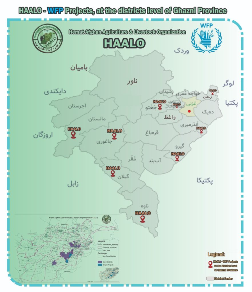
“Hemat Afghan Agriculture & Livestock Organization (HAALO) has implemented the necessary projects with the financial assistance of World Food Program (WFP) in the following district of Ghazni province, which is currently ongoing; the Brief information is as follows”
In this district with the efforts and implementation of HAALO, basic food items have been distributed to (2500) deserving and the poor needy families through the UCSS- (ER-GFD) project with the financial support of WFP from 2021, which this series even continues.
- Wali Muhammad (Khugyani) district:-
Wali Muhammad Shahid (Khugyani) is a district in Ghazni province, Afghanistan. It was previously part of Jaghatu District. To the east it is surrounded by Ghazni City District, to the south by Waghaz District, to the west by Jaghatu District, to the north by the Rashidan district and to the Northeast by Khwaja Umari district. It occupies 147 km2. The population is more than 22,719 people; Wali Muhammad Shahid (Khugyani) District has around 84 villages. This district, also known as Khugyani, is predominantly rural and relies on agriculture and livestock for the local economy, the district center is Khogyani.
“Hemat Afghan Agriculture & Livestock Organization (HAALO) has implemented the necessary projects with the financial assistance of World Food Program (WFP) in the following district of Ghazni province, which is currently ongoing; the Brief information is as follows”
In this district with the efforts and implementation of HAALO, basic food items have been distributed in 68 villages, to (520) deserving and the poor needy families through the UCSS- (ER-GFD) project with the financial support of WFP from 2021, which this series even continues.
- Jaghori district:-
Jaghori is one of the main districts of the Ghazni province in Afghanistan. It is located in the highlands in the southern fringes of the Hazara region. It occupies 1,965 km2. The population is estimated to be around 162,162 in 2015. Jaghori District has around 429 villages. This district is known for its relatively higher level of education and better living standards compared to some other regions in the province. The district capital, Sange-e-Masha, is where major business transactions take place. The district is heavily dependent on agriculture, and migrant workers as the main sources of income. Other major marketplaces are in Ghojor and Anguri.
“Hemat Afghan Agriculture & Livestock Organization (HAALO) has implemented the necessary projects with the financial assistance of World Food Program (WFP) in the following district of Ghazni province, which is currently ongoing; the Brief information is as follows”
In this district with the efforts and implementation of HAALO, basic food items have been distributed in 449 villages, to (2420) deserving and the poor needy families through the UCSS- (ER-GFD) project with the financial support of WFP from 2021, which this series even continues
- Malistan district:-
Malistan district is considered one of the largest districts of Ghazni province. It is located in the highlands in the southeastern fringes of the Hazara region, it occupies 1,978 km2. The population is estimated to be around 92,736 in 2015. Malistan is located in the southeastern part of Ghazni province, which is approximately 122 kilometers from Ghazni province. The terrain is mainly mountainous, and the district is a large part of Ghazni province known for its varied topography. Population: The district is home to a diverse population of different ethnicities. Exact population figures may vary, but generally include a high proportion of Hazaras and a very low proportion of other ethnic groups. Economy: The local economy is mostly based on agriculture and livestock. Due to the challenging terrain, agriculture is often limited to areas that have access to irrigation. Cultural and Historical Significance: Like most parts of Afghanistan, Malistan has a rich cultural heritage influenced by different historical periods and ethnic groups.
“Hemat Afghan Agriculture & Livestock Organization (HAALO) has implemented the necessary projects with the financial assistance of World Food Program (WFP) in the following district of Ghazni province, which is currently ongoing; the Brief information is as follows”
In this district with the efforts and implementation of HAALO, basic food items have been distributed in 288 villages, to (1789) deserving and the poor needy families through the UCSS- (ER-GFD) project with the financial support of WFP from 2021, which this series even continues.
- Jaghatu district:-
Jagtu district is a remote district in the east of Ghazni province. Here is a summary of important information about the fields. Geography: Jagtu is located in the central part of Ghazni province. The district is mainly mountainous and terrain, which affects the climate and accessibility. It occupies 696 km2. Population is estimated to be around 35,871 in 2015, consisting of different ethnicities and communities. Economy The economy of the country is mainly based on agriculture; most of its residents are engaged in agriculture and livestock. The economy of the region is also influenced by traditional industries and local businesses. Education and Infrastructure: Access to education and infrastructure in rural areas may be limited compared to developed areas. Efforts are underway to improve education and infrastructure, but challenges remain. Culture the cultural traditions and customs of the region are a reflection of the vast Afghan cultural heritage, where local traditions and customs play an important role in the life of the community.
“Hemat Afghan Agriculture & Livestock Organization (HAALO) has implemented the necessary projects with the financial assistance of World Food Program (WFP) in the following district of Ghazni province, which is currently ongoing; the Brief information is as follows”
In this district with the efforts and implementation of HAALO, basic food items have been distributed in 288 villages, to (1789) deserving and the poor needy families through the UCSS- (ER-GFD) project with the financial support of WFP from 2021, which this series even continues.
- Zana Khan district:-
Zana Khan District is a mountainous district in Ghazni province, it occupies 284 km2. With more than 14,215 people living there, Zana Khan District has around 67 villages the district center is Dado.
The district is within the heartland of the Andar tribe of Ghilji Pashtuns. Continuing drought is the main problem as in the whole province. It seriously affects agriculture, the main source of income. Health and education services need serious improvement.
“Hemat Afghan Agriculture & Livestock Organization (HAALO) has implemented the necessary projects with the financial assistance of World Food Program (WFP) in the following district of Ghazni province, which is currently ongoing; the Brief information is as follows”
In this district with the efforts and implementation of HAALO, basic food items have been distributed in 40 villages, to (800) deserving and the poor needy families through the UCSS- (ER-GFD) project with the financial support of WFP from 2021, which this series even continues.
- Giro district:-
The Giro District is located within southeastern Ghazni province in Afghanistan, 50 km South East of Ghazni city. The district is a wide plain with scattered low mountains. It occupies 878 km2. More than 41,319 residents are estimated, Giro District has around 113 villages, and the district is within the heartland of Ghilji Pashtuns. The district center is Pana. As the other districts in this area, it is seriously affected by the continuing drought. Harvests have been decreasing in recent years, and agriculture is the primary source of income, the roads are in bad condition. The health and education services need much improvement.
“Hemat Afghan Agriculture & Livestock Organization (HAALO) has implemented the necessary projects with the financial assistance of World Food Program (WFP) in the following district of Ghazni province, which is currently ongoing; the Brief information is as follows”
In this district with the efforts and implementation of HAALO, basic food items have been distributed in 113 villages, to (9810) deserving and the poor needy families through the UCSS- (ER-GFD) and MCBP projects with the financial support of WFP from 2021, which this series even continues.
- Gilan district:-
Gilan District is a district of Ghazni Province in the southeast of Afghanistan. Geography Gilan is located in the central part of Ghazni province and is characterized by mountainous terrain and valleys. The population is diverse, including various ethnic groups, mainly Pashtuns. Economy The economy is primarily based on agriculture, with residents growing crops such as wheat, barley and vegetables. Animal husbandry is also common. Education and Health Care Education and health care facilities are limited in Gilan, efforts are underway to improve these services in rural areas. Cultural Aspects Gilan, like most parts of Ghazni province, has a rich cultural heritage with Afghan customs and traditions. However, infrastructure in Gilan is underdeveloped compared to most urban areas, with roads and basic services requiring significant improvement. It occupies 1,116 km2. Its population was estimated at 65,366 in 2002, Gilan District has around 158 villages. The district capital is Janda, The district is within the heartland of the Tarakai tribe of Ghilji Pashtuns.
“Hemat Afghan Agriculture & Livestock Organization (HAALO) has implemented the necessary projects with the financial assistance of World Food Program (WFP) in the following district of Ghazni province, which is currently ongoing; the Brief information is as follows”
In this district with the efforts and implementation of HAALO, basic food items have been distributed in 158 villages, to (1200) deserving and the poor needy families through the UCSS- (ER-GFD) project with the financial support of WFP from 2021, which this series even continues.
- Nawa district:-
Nawa district is one of the districts of Ghazni province , centered on Surkali in the south-eastern part of Afghanistan . Naveh has an area of it occupies 1,753 km2. And its population in 2019 is about 33,613 people, Nawa District has around 132 villages. This district, like many others in the region, is primarily rural with a strong emphasis on agriculture and livestock. Nawa district is one of the second-level districts of Ghazni province, which is located in the north of Gilan district , in the east of Paktika province , and in the west of Zabul province.
“Hemat Afghan Agriculture & Livestock Organization (HAALO) has implemented the necessary projects with the financial assistance of World Food Program (WFP) in the following district of Ghazni province, which is currently ongoing; the Brief information is as follows”
In this district with the efforts and implementation of HAALO, basic food items have been distributed in 68 villages, to (520) deserving and the poor needy families through the UCSS- (ER-GFD) project with the financial support of WFP from 2021, which this series even continues.
More regarding Hemat Afghan Agriculture & Livestock Organization (HAALO)
- Name of the Organization: Hemat Afghan Agriculture and Livestock Organization/HAALO
Main Office: First Aino Mena, Street No. 17, House No. 764, Kandahar, Afghanistan.
- Sub Office: Beside Roshan regional office, 3rd Plan, Ghazni City, Afghanistan.
- Contact Person: Dr. Habib Rahman Hemat, Chief Executive Officer.
o Contact No. 0093 700349239
o Whatsapp No. 0093 792404644 (Mob).
Email address: haalo.1@hotmail.com/ info@haalo.af
- Registration Authority: Afghanistan Ministry of Economy
- Registration Number:2711
- Registration Date: SEP – 04 – 2012
- Year of Establishment: SEP – 04 – 2012
The End.